A staff report to the Santa Monica Planning Commission provides an update on long-running plans to convert Santa Monica Airport into a sprawling public park.
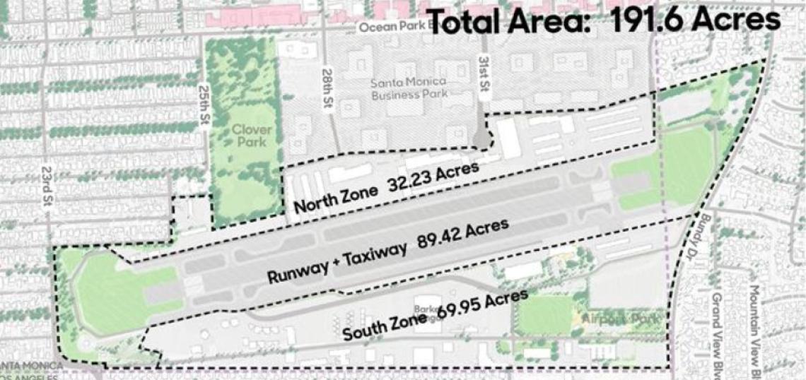
Under an agreement forged between the Federal Aviation Administration and the City of Santa Monica in 2017, the airport is slated to cease operations on December 31, 2028. City officials have looked to transform the 200 acre airport site - which spans between Bundy Drive and 23rd Street - to be converted to park space. That desire was codified in 2014 through the adoption of Measure LC, which expressly limits the future use of the land to open space or recreation areas unless approved by voters.
Community outreach to shape the design of a future park at the airport site commenced in 2024, and after thousands of responses and numerous public meetings, planners have arrived at three draft scenarios for the airport site.
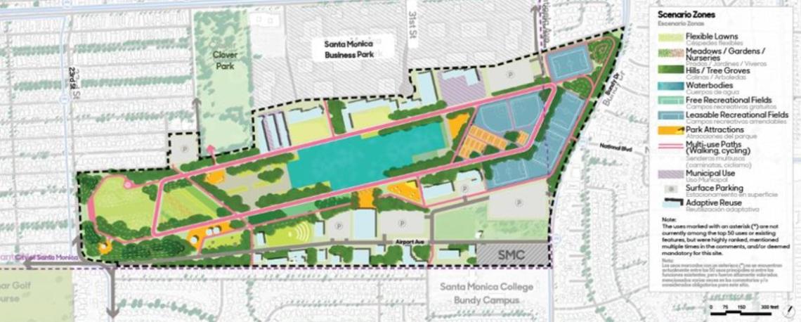 Scenario 1: Reuse, Restoration and ResilienceCity of Santa Monica
The first scenario named "Reuse, Restoration, and Resilience," is the heaviest on green space, adding new water features, sports fields, multi-use paths, and municipal facilities. Surface parking lots dot the southern side of the park, and development within the airport footprint is limited to the adaptive reuse of existing structures.
"The design explores a network of parks and public spaces carved out of the runway, providing spaces for nature, restoration, wellness, and community, in balance with recreational and arts programs and municipal opportunities," reads a narrative.
Specific elements would include five miles of new trails, 13 acres of public parking lots, a 15-acre municipal reservoir with no municipal uses, 15 acres of urban forest, 8 acres of meadows, a 5-acre community farm, 22 acres of sports facilities (including soccer fields, baseball diamonds, pickleball courts, tennis courts, and basketball courts), a 2-acre, 2,0000-seat amphitheater and event lawn; fitness stations and an outdoor gym, and a nature playground.
This option would take the longest time to implement, according to the presentation, and may also prove the most difficult to finance. The first scenario offers the least potential for on-site revenue generation, due to limited development (including 0 units of new housing). Revenue generation could include the leasing of existing buildings, paid parking, park concessions, and events.
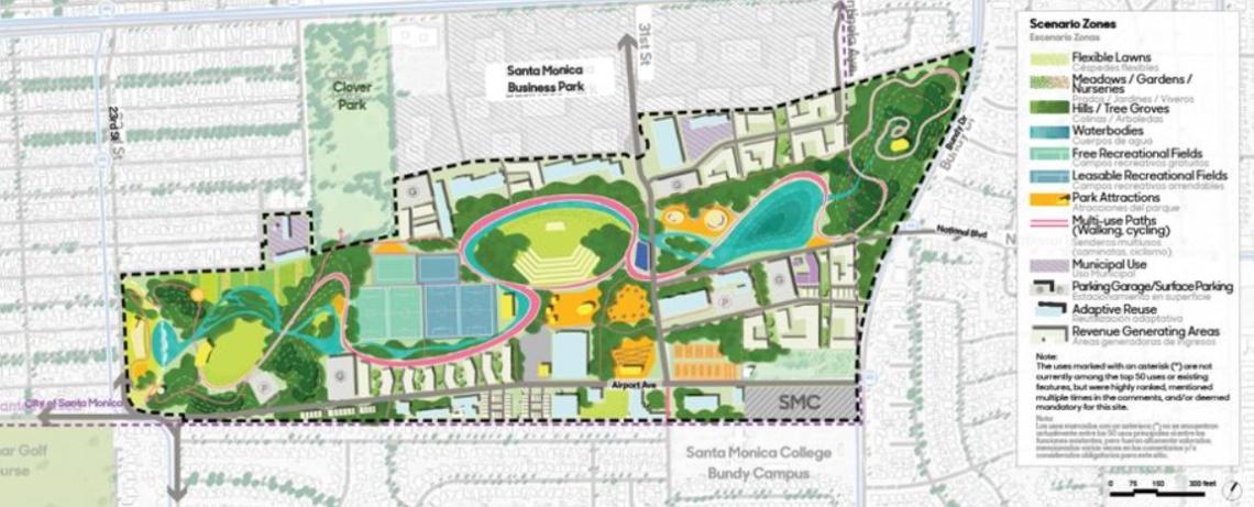 Scenario 2: Weaving Park and CommunityCity of Santa Monica
The second scenario, called "weaving Park and Community" offers a similar blend of open lawns, water features, recreation areas, walking paths, and parking.
"The park is artistically structured around a meandering multi-use path called 'The Bend', creating a rich tapestry of cultural and ecological places through the sculptural introduction of water, topography, and circulation," states a narrative.
Scenario two could include 4 miles of new pedestrian and bike trails, 3 new roads, streetscape improvements, 5 acres of surface parking, 1 transit hub, a 7-acre pond, a water treatment plant, 34 acres of urban forest, 21 acres of additional landscaped space, 6 acres of indigenous gardens and nursery, 5 acres of leasable sports fields, 5 acres of free sports fields, a 7-acre outdoor performing arts center, and 3 acres of dining areas.
Notably, in addition to the preservation and reuse of existing airport buildings, this option would include 32 acres of new housing and commercial development along the northern and southern perimeters of the site which could generate revenue for operations and construction. Accordingly, this alternative is indicated to have a speedier delivery time compared to the first scenario, with greater on-site revenue potential.
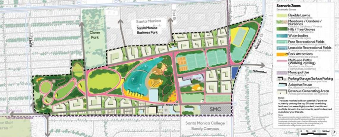 Scenario 3: Growing Park, Growing CommunityCity of Santa Monica
The third scenario, "Growing Park, Growing Community," is the most development intensive of the proposed alternatives.
"The site becomes the newest neighborhood of the City, with the City's largest public park framed by new residential opportunities," states a narrative. "This new community and park is centered on a grand recreational lake and waterfront."
This option would include 6 miles of new trails, 6 primary roads, streetscape improvements, 1 acre of surface parking for park users, a 10-acre lake, 17 acres of urban forest, 12 acres of other landscaped areas, 12 acres of botanical collections and community gardens, 21 acres of free public sports fields, a new aquatics and recreation center, a 2,000-seat amphitheater, 2 acres of playgrounds, and 3 acres of dining areas.
With 48 acres of the site reserved for commercial and housing development, the third scenario is also projected to be built in a shorter timeframe than its counterparts, and has the greatest amount of on-site revenue generating potential.
The notion of incorporating housing or commercial development into the airport site is described as contentious in the staff presentation, and would require a public vote in accordance with Measure LC. Responses yielded through public outreach favored alternatives which did not lean as heavily into providing new housing or revenue generating opportunities within the airport space, although an openness to senior, workforce, and affordable housing saw some support. All three alternatives would set aside at least two thirds of the airport site as open space.
An ultimate preferred scenario, scheduled to be selected in Fall 2025, will likely incorporate elements of all three of the scenarios presented to the Planning Commission.
Follow us on social media:
Twitter / Facebook / LinkedIn / Threads / Instagram / Bluesky
- Santa Monica Airport Park (Urbanize LA)