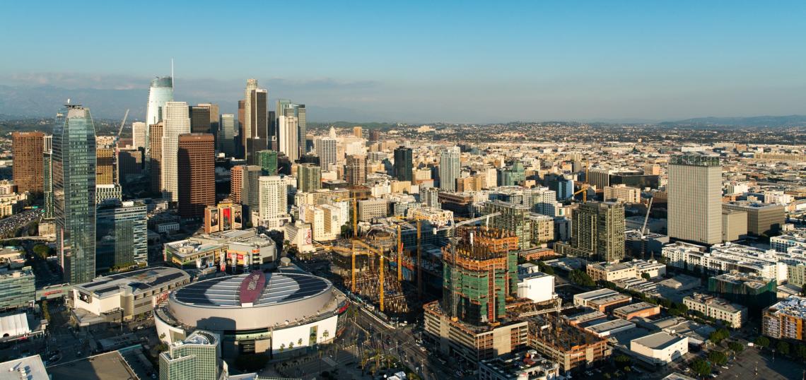
Since the late 1990s, a construction boom has transformed Downtown Los Angeles from a sleepy office district into a thriving urban hub. The City is now looking to guide the next 20 years of development in the neighborhood through the DTLA 2040 process, which will update both the Central City and Central City North community plans.
In the more than 15 years since the two plans were last updated, Downtown's population has doubled from an estimated 27,849 residents to nearly 60,000 today. In addition to a plethora of large commercial and residential developments, this population boom has coincided with a number of transportation improvements affecting the neighborhood, including the Metro Bike Share program and extensions of both the Expo and Gold Lines. Other infrastructure projects with relevance to Downtown include the new Regional Connector subway, the California High Speed Rail system and a proposed streetcar system.
In planning for the future, the City is considering forecasts by the Southern California Association of Governments, which predict more and additional 125,000 residents, 70,000 housing units and 55,000 jobs in Downtown by the year 2040. The guiding principals in this effort are:
Reinforce Downtown's Jobs Orientation
- Maximizing job intensity in the most transit-served areas
- Expanding the areas where mixed use is allowed
- Setting locations where commercial activity is preferred
- Establishing locations that must maintain a baseline of productive capacity when introducing housing
- Encouraging mixing in single-use areas
Grow and Support the Residential Base
- Promoting infill development
- Expanding areas where housing is allowed
- Intensifying housing where appropriate
- Creating new housing typologies
- Expanding areas for adaptive reuse and for conversion to joint live/work units
Strengthen Neighborhood Character
- Reusing, protecting and preserving existing structures that characterize unique urban development patterns
- Supporting streets for pedestrians
- Providing a palette of building frontages catering to the range of community characteristics
- Using design guidelines, use restrictions and design regulations
- Allocating greater development potential around transit centers
- Providing guidelines for business establishment sizes
Create Linkages Between Districts
- Finding opportunities within a public benefits system for the development of new publicly accessible open space
- Engouraging the development of nontraditional open spaces
- Requiring new development to contribute to high quality streets
- Treating the streets as downtown’s living room
- Supporting the creation of sustainable public realm improvements
- Encouraging programming of public space to build community
Promote Transit, Bicycle and Pedestrian Friendly Environment
- Prioritizing and expanding pedestrian safety tools such as leading pedestrian intervals, bulb outs, scramble crosswalks, and no right turns on red
- Improving connectivity
- Increasing dedicated bike infrastructure
- Eliminating one-way streets as feasible and appropriate
- Extending nighttime and weekend transit service
- Discouraging over parking and above-grade parking
- Managing and pricing parking effectively
- Supporting an efficient goods movement system
A plan concept map, seen on the DTLA 2040 plan's official website, breaks Downtown into an assortment of "place types" that are similar in terms of built environment and functionality.
Transit Core (Max FAR 13:1)
Transit Core areas are dense centers of activity built around regional transit hubs that provide easy access for pedestrians, transit users, and cyclists to a variety of experiences and activities. These places provide a high-energy urban experience, with towers activated by ground-floor retail that engages and invites pedestrians. Buildings have high-quality design and provide visual interest. Enhanced streetscapes, paseos, and alleys create a seamless network of walkable paths that balance the high-intensity built environment. A diverse mix of office, residential, retail, cultural, and entertainment uses makes these places centers of activity around the clock.
Neighborhoods given the transit core distinction include South Park, the Financial District, Bunker Hill and El Pueblo.
Traditional Core (Max FAR 8:1 - 13:1)
Traditional Core places have a time-honored urban development pattern and a rich collection of historically-significant buildings. The protection, restoration, and reuse of these structures is a priority. New development responds to this predominant urban form, contributing to the pedestrian-oriented environment with active alleys and inviting shopfronts. Historic design features and blocks are built out edge-to-edge, contributing to a distinctive sense of place. Residences and offices above entertainment venues, neighborhood-serving stores, and restaurants draw local, regional, and international visitors, supporting activity around the clock.
The Traditional Core designation is given to the Historic Core.
Industrial Preserve (Max FAR 3:1)
Industrial Preserve areas protect and sustain industrial activity while serving as a regional jobs base for a range of training skills and education levels. Buildings in these areas are flexible, high-quality structures that accommodate evolving and innovative industries including light assembly and manufacturing, clean technology, incubators, and research & development facilities. The large-format structures in flexible lot configurations balance goods movement, loading, and distribution needs with pedestrian-scaled design that supports a healthy environment for all users.
The land designated as Industrial Preserve is located in the southeast Arts District.
Markets (Max FAR 3:1 - 6:1)
Market areas are comprised of medium-scale buildings that accommodate wholesale, commercial, retail, limited housing, and goods movement activities. As bustling centers of commercial activity, these places are characterized by porous, fine-grained blocks – each with its own mini-economy of specialized commercial offerings. At each of these nodes, local and regional patrons spill out from the storefronts on to sidewalks and active alleys, creating a high-energy street life that is sustained throughout much of the day and night. Adaptive-reuse and rehabilitation of existing structures and warehouses maintains the unique character and supports sustainable development.
Both the Fashion District and Industrial District have been given the Market designation.
Civic (Max FAR 8:1)
Civic place types are home to governmental, institutional, and cultural functions for the City. Civic places serve as centers of democratic practice and public life. A variety of structures, site layouts, and building designs flexibly support civic activity, improve internal circulation, and contribute to an active public realm. Public spaces are prevalent and integral to these places, creating a lively atmosphere with frequent programming and public events. Retail, office and hotel uses are integrated with civic uses, encouraging street life and extending hours of activity beyond the work day.
This designation largely applies to the Civic Center.
Hillside Neighborhood (Max FAR 3:1)
Urban Hillside neighborhoods are traditional, walkable, and compact single, and multifamily residential areas with flexible buildings that accommodate aging populations. A limited number of small, local-serving retail establishments are integrated into the residential fabric. Buildings are oriented toward the street with traditional neighborhood features, such as stoops and small landscaped yards, which contribute to an inviting public realm. These areas accommodate pedestrians, cyclists, and local traffic. These neighborhoods are adjacent and connected to commercial and employment centers.
Hillside neighborhoods include Victor Heights and portions of Chinatown.
Villages (Max FAR 4:1 - 6:1)
Villages are characterized by charming, small-scale, and porous development. Retail uses on the ground floors of active streetsand alleys in these areas provides a lively and safe pedestrian atmosphere. A range of housing types for all incomes and family sizes are integrated with commercial uses such as restaurants, retail, services, and small professional offices to create complete neighborhoods. These walkable centers serve as historic and cultural regional niche market destinations. Adaptive reuse of historic structures and infill development on small lots is responsive to the historic and cultural legacy of these areas.
Villages include Chinatown and Little Tokyo.
Hybrid Industrial (Max FAR 3:1 - 6:1)
Hybrid Industrial places have a distinct urban form characterized by medium and low scale development with an industrial legacy. High-quality new construction and repurposed structures collectively promote a resourceful approach to urban development that can evolve over time. These areas preserve productive activity and prioritize space for employment, including light industrial, new industry, commercial, and vertically-integrated businesses,with careful introduction of live-work uses. The industrial legacy is reflected with a network of irregular streets, punctuated by occasional passageways. The street, block and building pattern has evolved into an inviting environment for pedestrians and cyclists.
The Hybrid Industrial zone includes the Arts District and portions of the Industrial District.
Transit Edge (Max FAR 8:1 - 10:1)
Transit Edge areas are complete urban neighborhoods & vibrant centers of activity. These secondary transit nodes have a regular street grid and active alleys. Mid-rise buildings have strong street walls and active ground floors reinforcing the urban character of these areas. Key pathways between regional transit resources and adjacent activity centers enhance the pedestrian experience and provide clear wayfinding between adjacent Place Types. Residential, office, and community commercial uses are integrated to create balanced centers of activity. High-quality streetscapes and public spaces provide amenities to workers, residents, and visitors and promote a pedestrian-friendly environment.
Portions of South Park, the Arts District and Little Tokyo have been designated as "Transit Edge" areas.
Some, including Shane Phillips of Better Institutions, have argued that the DTLA 2040 plan does not go far enough, placing too much emphasis on on preservation and too little on improving housing affordability. Of particular concern is that the proposed industrial preserve would not allow for residential uses, despite the well-documented decline of manufacturing jobs within Downtown.
A scoping meeting for the DTLA 2040 plan is scheduled for February 16 at the Civic Center's Caltrans Building.
- DTLA 2040 Archive (Official Website)