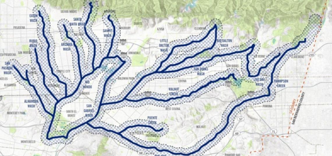
Back in 2017, the Los Angeles County Board of Supervisors voted to use the flood control systems along the San Gabriel and Rio Hondo watersheds to create a network of community greenways. An environmental study published by the Los Angeles County Department of Public Works marks a key step in that effort.
The environmental study, which covers approximately 140 linear miles of waterways within the San Gabriel Valley, would help to establish design standards and facilitate agreements with partner agencies to help expedite projects within the plan area. The main aim of the project is an overall greenway path, making use of unused or underutilized right-of-way within flood control channels, while also providing space for new pocket parks, street crossings, furniture, street safety improvements, trees, and stormwater infrastructure.
Waterways included in this plan area are:
- The Alhambra Wash, which spans 4.7 miles through San Gabriel, Alhambra, Rosemead, and unincorporated Los Angeles County. This corridor is described as being challenging to improve upon due to a constrained right-of-way with complex intersections and jurisdictional interests.
- The Arcadia Wash, spanning five miles through Pasadena, Arcadia, and North El Monte, offers an easier opportunity for adding greenway infrastructure, albeit with a large section which is placed underground to the north of Huntington Boulevard and several large street crossings.
- Big Dalton Wash, spanning 16.6 miles from the Angeles National Forest through El Monte, Baldwin Park, and Glendora, has a wide right-of-way capable of hosting a greenway, and vacant publicly-owned parcels which could become park space.
- Eaton Wash, spanning 8.1 miles from Pasadena through Temple City and Rosemead, has a wide right-of-way capable of housing a greenway, albeit with some underground segments and challenging intersections.
- Little Dalton Wash, which runs 6.7 miles from the Angeles National Forest to the San Gabriel River through Glendora, Citrus, and Covina, also has available right-of-way along its full length.
- San Dimas Wash, Puddingstone Channel, and Live Oak Wash are grouped together for the environmental study, and pass through the communities of Citrus, Vincent, Covina, San Dimas, Claremont, La Verne, and Pomona. They are described as having sufficient right-of-way to accommodate a greenway at several locations, albeit with some complications due to existing easements.
- Puente Creek, which runs four miles through West Covina, Valinda, West Puente Valley, La Puente, and Hacienda Heights, has been identified as an opportunity for a greenway and bike trail in several prior studies.
- Rubio Wash, which runs five miles through San Gabriel, Rosemead, and South El Monte, is described as having a constrained right-of-way that would require a complex design to implement greenway infrastructure.
- San Jose Creek, running 24 miles through San Dimas, Diamond Bar, Pomona, Walnut, Valinda, Hacienda Heights, and Industry, already has a short bikeway at its western end, and has been identified as a greenway corridor in the Los Angeles County Bicycle Master Plan.
- Santa Anita Wash, running 6.3 miles from the San Gabriel Mountains near Monrovia through Arcadia and El Monte, is already the site of a short planned greenway, and much of the land falls under County control, making implementation easier.
- Sawpit Wash, spanning 4.9 miles from Monrovia to North El Monte, has been identified as a greenway priority by the surrounding area, and has several vacant government-owned parcels along its corridor that could be converted into parks or amenities.
- Thompson Creek, spanning 5.9 miles from Claremont through Pomona, has a wide right-of-way along most of its bank, providing more than sufficient space for a greenway, as well as proximity to opportunity sites for parks.
- Walnut Creek, running 7.7 miles through La Verne, San Dimas, Charter Oak, Covina, West Covina, Valinda, Vincent, and West Puente Valley, has a wide right-of-way and potential connections to several existing trails.
However, the study notes that early assessments have identified 64 potential parks or green spaces within the project area - the largest of which could be up to 25 acres on a site near the Pomona Fairgrounds. Likewise, the study notes that new bridges and crossings - some up to 400 feet in length - would be required to pass over intersections, roads, bridges, or railroads at numerous locations.
The study also lists 10 conceptual example projects, which have not been funded or planned, but represent the type of improvements being contemplated. They include:
- Alhambra Wash at Vincent Lugo Park - a 1.3-mile trail along the Alhambra Wash between Mission Road and Hovey Boulevard;
- Big Dalton Wash at Hilda L. Solis Park - a 1.8-mile trail along the east bank of Big Dalton Wash between Hilda Solis Park and Irwindale Avenue, with a connection to the recently-finished Vincent Community Bikeway Project;
- Eaton Wash Greenway and Spreading Ground Site - 2 miles of greenway paths from Woodlyn Road and Blanche Park with a bridge park, a garden, and a rest area;
- Eaton Wash at Eaton Blanche Park - open space and landscape improvements to Eaton Blanche Park, connecting to phase one of the Eaton Wash Bike Path between Longden Avenue and Rosemead Boulevard;
- San Dimas Wash at Arrow High School - improvements to the intersection and crossing in front of Arrow High School at Gladstone Street and Sunflower Street, with a potential connection to the school yard and the existing San Dimas Wash trail;
- San Dimas Wash at Hollenbeck park - a 1.5 mile path from Lark Ellen Avenue to Citrus Avenue;
- San Jose Creek at Pocket Park - a 2.3-mile segment of greenway starting at Workman Mill Road to 7th Avenue;
- Thompson Creek at the Fairplex - a 3.3-mile greenway from the Pomona North Metrolink Station to the Fairplex;
- Walnut Creek at Syhre Park - a 2.9-mile greenway from Baldwin Park Boulevard to Sunset Avenue, connecting to the Big Dalton Wash Trail Greening Project; and
- Walnut Creek at Pocket Park - a 2.2-mile greenway from Glendora Avenue and Valinda Avenue to Citrus Street, connecting with an existing bike path between Lark Ellen Avenue and Azusa Avenue.
As the environmental report evaluates improvements to a large area rather than any individual project, a precise timeline for construction and implementation is not estimated.
Find out more about the San Gabriel Valley Greenway Network Strategic Implementation Plan here.
Follow us on social media:
Twitter / Facebook / LinkedIn / Threads / Instagram / Bluesky