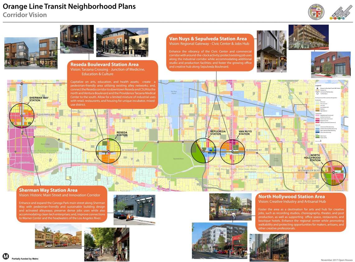
Last month, the Los Angeles City Planning Commission approved the proposed Exposition Corridor Transit Neighborhood Plan. Now the City turns its eyes towards similar land use and zoning regulations for stations around the San Fernando Valley's popular Orange Line busway.
Although the Orange Line covers 18 miles and 18 stations between Chatsworth and North Hollywood, the proposed Transit Neighborhood Plan (TNP) only targets five stations: Sherman Way, Reseda, Sepulveda, Van Nuys and the North Hollywood terminus. Each of these stops is located along key arterials with connections to other local bus routes.
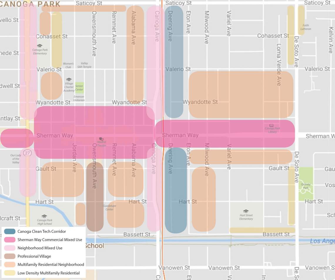
To both sides of the Orange Line, Sherman Way is lined with a number of legacy commercial storefronts, owing to its history as the "main street" of Canoga Park. Through the Orange Line TNP, the City hopes to reinforce this status by mandating pedestrian-friendly building design, activating alleyways, preserving job uses on surrounding industrial properties and improving connections to Warner Center and the Los Angeles River.
The initial concepts envisions six different zones within a nearly 550-acre are roughly bounded by Topanga Canyon Boulevard to the west, the Los Angeles River to the south, De Soto Avenue to the east and Saticoy Street to the north.
Sherman Way is imagined as a "commercial mixed-use" area featuring multi-story buildings with residential units atop ground-floor retail uses. Maximum building heights would range from two-to-four stories west of Canoga Avenue, in an effort to preserve the lower-scale appearance of Canoga Park's historic business district. Taller structures would be permitted to the east of Canoga, with maximum allowable heights between four and seven stories. Maximum floor area ratios would be restricted to either 2:1 or 3.75:1 based on the same dividing line.
The initial concepts also call for the reuse of existing buildings by allowing for changes of use without requiring additional parking.
Two of the main north-south corridors within the Sherman Way Station area - Topanga Canyon Boulevard and Canoga Avenue - would be designated for "neighborhood mixed-use, which calls for pedestrian-oriented retail space at the ground level of new construction. Topanga Canyon would allow buildings between one and four stories in height, with maximum floor area ratio between 2.0 and 3:0. Canoga Avenue would allow for more intense development, with maximum heights between four and seven stories and maximum FAR between 3.0 and 4.2.
The industrial properties located immediately east of the Orange Line right-of-way, a legacy of the busway's origins as a freight rail corridor, are being dubbed the "Canoga Clean Tech Corridor." The intent of this zone would be to retain the area's employment focus and encourage the establishment of cleantech businesses within the area. Although it would allow for limited residential development, such projects would be restricted to areas located farther from the station.
Heavy industrial uses would be restricted in this zone, with the City instead hoping for a mix of creative office space, business incubators, light industrial and some restaurants and retail space. The maximum FAR in this area would range from 1.5 to 4.0, while building heights could range from three to seven stories at properties located close to the station, and one to four stories for those located farther from the station.
Owensmouth Avenue, which runs north-to-south through the station area, is considered the area's main access point to both Warner Center and the Los Angeles River. The Orange Line TNP proposes a corridor lined with office- and multi-story mixed-use buildings between Gault Street and the river, with building heights between two and six stories and maximum FAR between 2.0 and 3.75.
The plan calls for existing multifamily zones to remain as such, with allowable building heights between three and six stories and maximum FAR between 3.0 and 3.5. Additionally, the initial concepts consider expanding the multifamily zones onto several blocks that are currently zoned for single-family residential development. These properties are located in areas that are already predominantly built out as multifamily residential neighborhoods.
Several strips of single-family residential properties along major streets - such as De Soto - could be designated for low-density multifamily residential uses. This would promote the development of "missing middle" housing types, such as townhomes, duplexes, fourplexes, bungalow courts and small lot subdivisions. Maximum heights for these properties would range between one and three stories, and maximum FAR would range between 3.0 and 3.5.
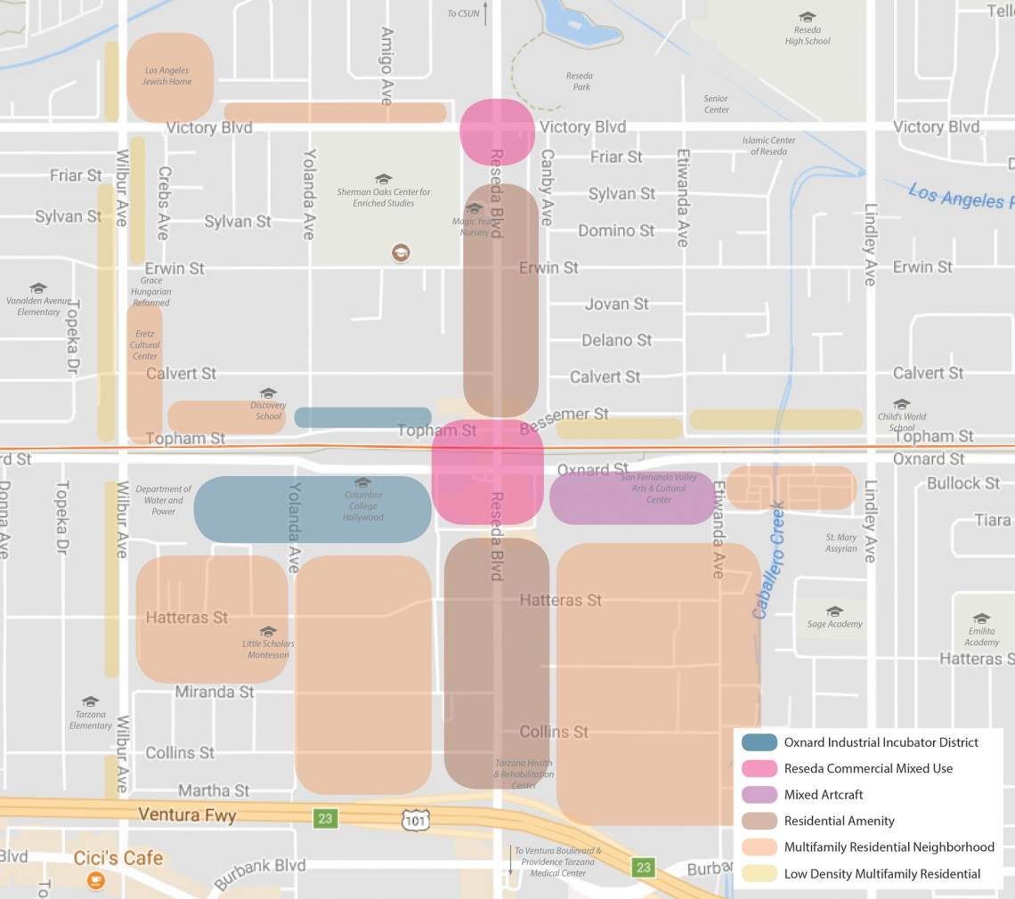
Reseda Boulevard, one of the most heavily trafficked north-south arterials in the Valley, is cast as a "junction of medicine, education, and culture." The plan looks to capitalize on the nearby presence of both Cal State Northridge and the Providence Tarzana Medical Center.
Like its counterpart at Sherman Way, the proposed Reseda Station plans envisions six tailored zones for major corridors and neighborhoods surrounding the busway.
Reseda's intersections at Oxnard Street and Victory Boulevard would be designated for commercial mixed-use, supporting active ground-floor retail uses and rear parking. This zoning would allow for maximum building heights between four and seven stories north of the Orange Line, and between five and nine stories south of the Orange Line. Maximum FAR would range from 2.0 to 3.75 north of the busway, and 3.0 to 4.0 south of the busway.
Moving east from Reseda Station, an existing tract of industrial land would be designated as "Mixed Artcraft," which would allow for light industrial uses and some retail and residential construction, while prohibited heavy industry. The designation would set maximum FAR between 3.0 and 4.0, and require that new construction upgrade an existing network of alleys for shared use.
A similar industrial tract to the west of Reseda Station would be dubbed the Oxnard Industrial Incubator District. The proposed land use regulations would preserve the area's employment focus, promoting cleantech jobs, incubators, light manufacturing and some retail and restaurant space. Heavy industrial uses would be prohibited, and residential development would be restricted to the area north of the Orange Line. Maximum FAR in this district would be set between 2.0 and 2.5 north of the Orange Line, and between 3.0 and 4.5 to the south of the Orange Line.
Properties lining Reseda Boulevard is proposed as a residential amenity district, which allows for multi-family residential uses and some neighborhood-serving commercial uses, including daycares and cafes. Allowable building heights would range between two and seven stories, and maximum FAR would be set between 3.0 and 4.0.
Existing blocks of apartments off of the major corridors would be set for continued multifamily residential development, with building heights between three and six stories and maximum FAR between 3.0 and 3.5.
Lastly, several stretches of single-family homes along major corridors - including Wilbur Avenue, Victory, and Oxnard - could be designated for low-density multifamily residential, which is intended to promote moderate density development. Maximum FAR would be set between 3.0 and 3.5, with building heights between one and three stories.

Van Nuys and Sepulveda Boulevards are arguably the two most important north-south spines of the Valley, with Van Nuys serving as its institutional and commercial heart, and Sepulveda as its primary link to the Los Angeles basin.
The Van Nuys Orange Line Station is located immediately south of the Van Nuys Civic Center, which houses satellite offices for several state and local government organizations, and will eventually become the terminus of a proposed bus or light rail line traversing Van Nuys Boulevard. Building off of this hub, the corridor north of the Orange Line Station is envisioned as a regional center and civic hub. New construction is envisioned as mixed-use, multi-story buildings, but the initial concepts also promote the reuse of historic structures by not requiring parking for change-of-use applications. Maximum building heights in this area would be limited by FAR, which is capped at levels between 3.0 and 4.0.
Sepulveda Boulevard and the portion of Van Nuys located south of the Orange Line are designed commercial mixed-use, which would facilitate multi-story buildings featuring ground-floor retail with habitable space above. Maximum FAR would be set between 2.5 and 3.5 for Van Nuys and Sepulveda, and between 2.0 and 4.0 for areas surrounding the Civic Center and at Sepulveda's intersection with Oxnard Street. Building heights would be limited to five stories along Van Nuys and Sepulveda, and restricted by FAR at the aforementioned intersections.
As with most of the Orange Line right-of-way, the section between Van Nuys and Sepulveda is lined with legacy industrial properties. The intial concepts look for the blocks located farther from the station sites to remain as such, incorporating cleantech businesses and limited live/work developments to transition to adjacent neighborhoods. Building heights would be regulated by maximum FAR, which would range between 1.5 and 4.5.
Multifamily properties along corridors such as Burbank Boulevard are proposed as residential amenity districts, which would allow for limited neighborhood-serving commercial uses, including day care centers and cafes. Building heights are limited to four stories along Burbank, Hazeltine Avenue, and Victory Boulevard between Kester and Sepulveda. Structures up to six stories in height could rise on Victory between Hazeltine and Kester. Maximum FAR for all residential amenity properties would range between 2.5 and 3.5.
Existing multifamily neighborhoods, mostly located north of the Orange Line, would remain as such. Proposed maximum heights are four stories south of the Orange Line, and five-to-six stories north of the Orange Line. Maximum FAR would vary from 3.0 to 4.0 between different areas.
As with the other station areas, the Van Nuys and Sepulveda Stations could see a handful of current single-family blocks rezoned to allow for lower intensity multifamily development - such as townhomes or small lot subdivisions. Maximum FAR would be set between 3.0 and 3.5, with building heights between one and three stories.
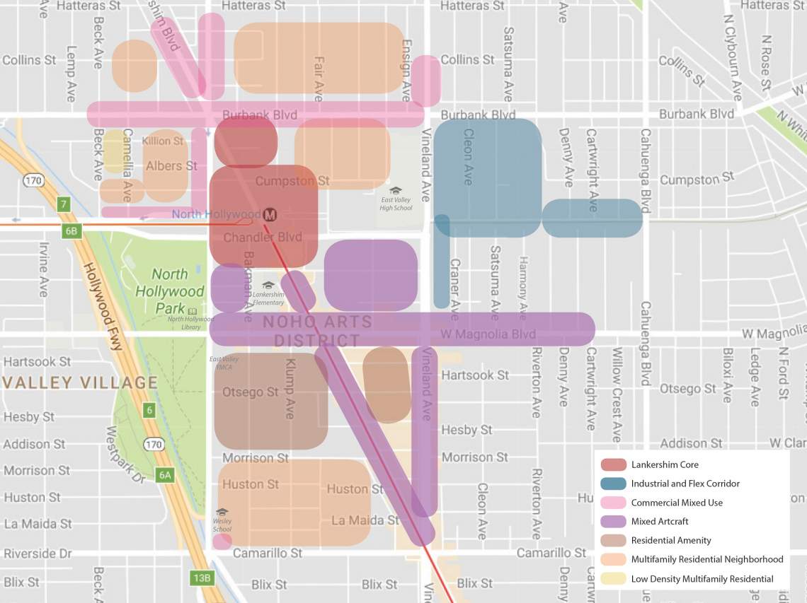
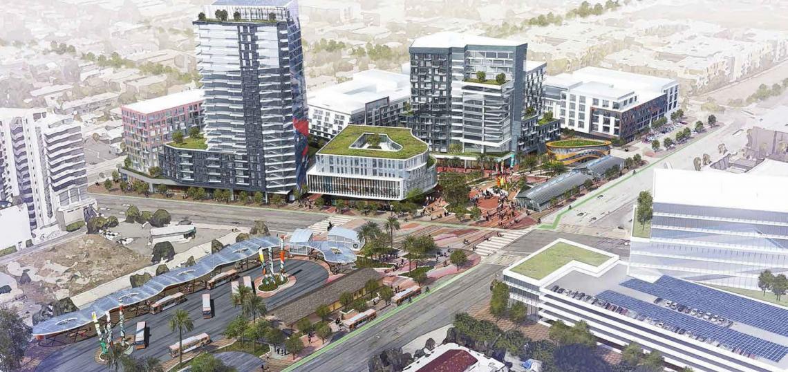
North Hollywood Station is the busiest transit center in the San Fernando Valley, as the shared terminus of both the Orange Line and the Red Line subway. In recent years, the surrounding area has in recent years become a walkable hub for the arts and creative jobs.
Under the initial concepts for the TNP, the immediate station area is dubbed the Lankershim Core, which would facilitate high-density commercial and residential development. Building heights are not explicitly regulated in this area, but are instead determined by maximum FAR, which is set between 3.0 and 6.0. The Lankershim Core includes North Hollywood's large park-and-ride facility, which is slated for a transformative mixed-use development from Trammell Crow Company.
Portions of Burbank, Chandler, and Lankershim Boulevards are given the commercial mixed-use designation seen in the other station plans. This facilitates multi-story buildings with active ground-floor uses capped with apartments, condos or office space. Maximum FAR for this zone is set between 2.5 and 6.0.
The proposed TNP rebrands a swath of industrial land located east of Vineland Avenue as an industrial and flex corridor, promoting light industrial uses and office space that would be compatible with adjacent residential blocks. Maximum FAR for this area is set between 2.0 and 4.0.
South of North Hollywood Station, Lankershim and Magnolia Boulevards would be designated as a "mixed artcraft" district, similar to the one planned near Reseda Station. This designation would maintain existing art and studio uses, while also allowing for residential and commercial development. A handful of mixed-use projects are already planned or under construction on these corridors, which would see maximum FAR set between 2.5 and 6.0.
Existing multifamily neighborhoods are would see maximum FAR between 3.0 and 4.0 under the proposed TNP, with maximum heights between three and seven stories. Some properties would be rezoned as residential amenity districts, which allow for community-serving commercial uses at the ground-level.
Housing, Open Space and Urban Design
The proposed TNP also includes a number of corridor strategies, designed to incentive affordable housing and public open space through development incentives. This could include relief from certain provisions of the zoning code, or additional development rights, in exchange for providing subsidized affordable units and publicly-accessible amenities such as courtyards and paseos.
Design regulations are tailored for a pedestrian emphasis, with the corridor strategies calling for strategically-placed driveways, screened parking, and active, transparent ground floors. The TNP also incorporates elements of re:code LA, the ongoing rewrite of the Los Angeles zoning code.
Next Steps
The Orange Line TNP is expected to begin its environmental review process in 2018, with revisions and updates to come in the wake of community feedback. Implementation is tentatively scheduled to begin in 2019.
- Orange Line TNP Project Updates (LATNP)