In 2016, the Los Angeles Department of City Planning launched DTLA 2040 – a multi-year update of the Central City and Central City East Community Plans that determine land use and development rules for the Downtown area. Though the final plan is still months away from publication, a draft document unveiled this week give a glimpse of what it will entail.
As of early 2019, the Downtown Center Business Improvement District estimated that Downtown Los Angeles is home to approximately 80,000 people. By 2040, the Southern California Association of Governments anticipates that the neighborhood will add 125,000 new residents. In the same period, the area is expected to add 55,000 jobs. The Downtown Community Plan would accommodate that growth by providing capacity for up to 176,000 additional residents and 86,000 new jobs.
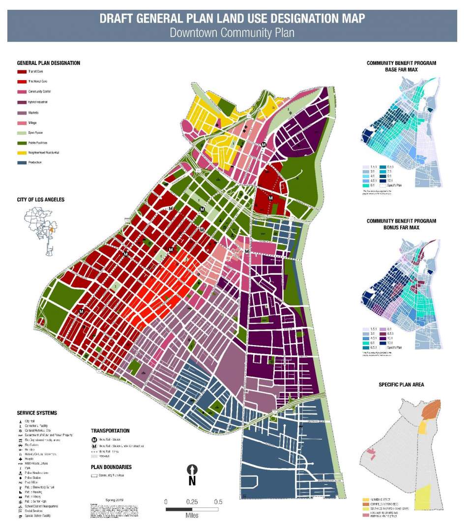
The proposed zoning divides Downtown between 10 land use designations, seen in the map below.
- Transit Core - dense activity centers built around transit hubs with an array of office, residential, retail, cultural, and entertainment uses (maximum FAR range: 10:1 - 13:1);
- Traditional Core - the neighborhood's historic center, featuring residences, offices, entertainment venues, neighborhood-serving stores, and restaurants (maximum FAR range: 8.5:1 - 13:1);
- Community Center - complete urban neighborhoods with low- and mid-rise buildings featuring residential, office, and commercial uses, centered on secondary transit notes (maximum FAR range: 6:1 - 8.5:1);
- Hybrid Industrial - areas with a distinct form characterized by an industrial legacy, now developed with light industrial, new industry, commercial, and live/work uses (maximum FAR range: 3:1 - 6:1);
- Markets - comprised of medium-scale buildings accommodating wholesale, commercial, retail, housing, and goods movement activities (maximum FAR range: 4.5:1 - 8:1);
- Villages - walkable centers serving as historic and cultural regional niche destinations, characterized by mixed-income housing, restaurants, retail, and small professional offices (maximum FAR range: 6:1 - 8.5:1);
- Neighborhood Residential - traditional, walkable areas with multi-generational populations and small, local-serving commercial establishments (maximum FAR: 3:1);
- Production - characterized by large-scale buildings housing light industrial, manufacturing, and offices uses (maximum FAR: 3:1);
- Open Space - parks and recreational facilities (maximum FAR: 1.5:1);
- Public Facilities - government, institutional, and cultural functions for the city, including offices, libraries, schools, medical facilities, and service systems (maximum FAR range: 1.5:1 - 13:1)
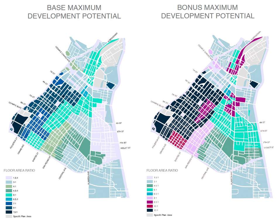
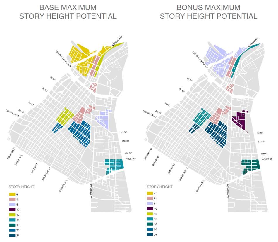
One of the key additions to the Downtown Community Plan, according to Clare Kelley, a City Planning Associate working on the update, is a community benefits program in the mold of the SB 1818 density bonus. This would take the form of a bonus concept in which applicants may build taller and denser if their projects incorporate public benefits - starting with affordable housing.
“This plan is accommodating roughly 20 percent of the city’s growth within 1 percent of its land area," said Craig Weber, a Principal City Planner. "So it is imperative that there is a thoughtful system to retain income diversity in the Downtown area.”
Under the proposed zoning, projects could achieve up to a 35 percent floor area bonus in exchange for providing a required number of on-site restricted affordable housing units in accordance with the state density bonus law. These restricted units may be priced for households earning 15 percent or less than the area median income, a new affordability level called "deeply low-income." The Planning Department incorporated the new category into the Downtown Community Plan after consulting with Skid Row stakeholders, who have argued that units priced for established affordability levels (moderate-, low-, very low-, and extremely low-income) are still out of reach for the homeless population.
Projects in eligible areas can also make use of the Transit Oriented Communities guidelines as an alternative to the community benefits program, if they so choose. The TOC incentives, which went into effect in 2017, have become a popular tool for residential developers to achieve greater height and density in many parts of Los Angeles. Due to the numerous bus and rail lines that intersect in Downtown, most properties in the Central City and Central City East community plan areas are eligible for TOC incentives.
A second tier of incentives would allow both residential and non-residential projects to achieve additional height and floor area increases through the provision of community benefits. Applicants may choose from a menu of options, including public open space, reserving space for a community land trust, and on-site community facilities such as a school or a library.
In some cases, such as the Arts District, the option of historic preservation may be one of those public benefits. Under the proposed zoning, applicants would be able to transfer the untapped development rights of a historic property to an off-site location. The existing buildings could then be retained and reused, and their unused floor area rights could be used to create a larger project elsewhere.
This process, also called a transfer of floor area rights (TFAR), is not new to Downtown Los Angeles. Developers of high-rise buildings in the Financial District, Bunker Hill, and South Park have long availed themselves of TFAR to build taller, denser projects than would otherwise be allowed. The existing TFAR program will be retained through the Downtown Community Plan update, but as an additive to the community benefits program rather than an alternative avenue for achieving greater development rights. A developer must first exhaust the bonuses available through the provision of affordable housing and community benefits before making use of TFAR.
An applicant developing a project according to base zoning would not be required to incorporate public facilities and affordable housing in accordance with the community benefits program. However, fees such as those for affordable housing production and park development would still apply.
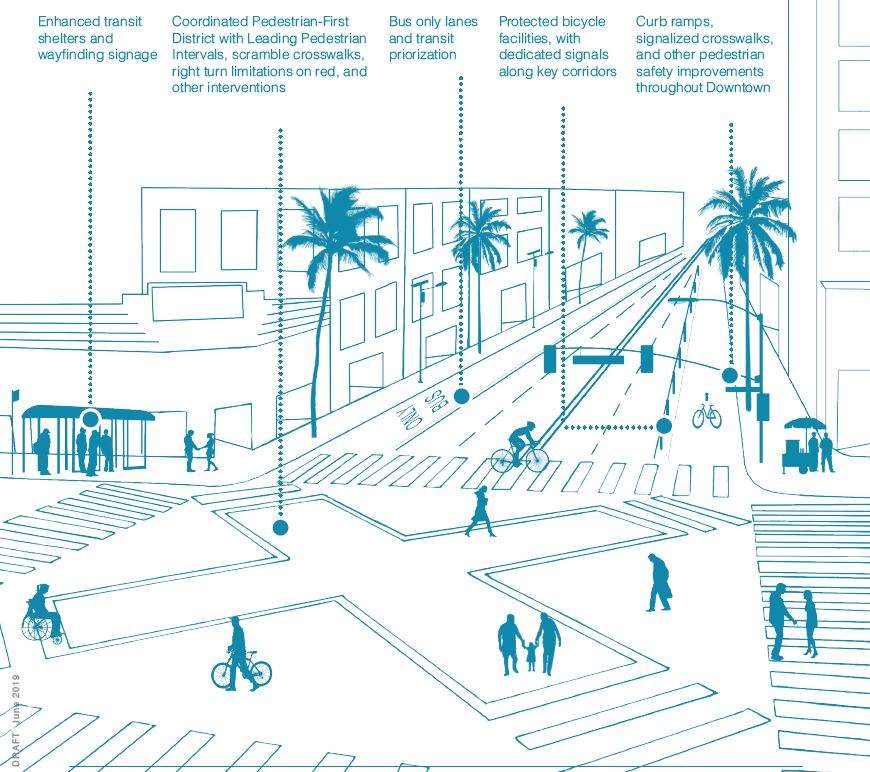
Beyond land use changes, the Downtown Community Plan also addresses issues such as mobility, urban design, and open space. Some of the goals put forth by the plan include:
- establishing a mode share goal of 75 percent of transit, walking, and cycling by the year 2040;
- enhancements to key east-west and north-south corridors to improve connections with adjoining communities;
- fostering the expansion of rail transit service to the eastern side of Downtown;
- eliminating parking minimums;
- developing new parks - including a large park in the Fashion District;
- reusing odd-angle intersections and dead end streets for public open space; and
- activating alleys for pedestrian circulation and green space.
Though numerous community plan updates are in process across Los Angeles, the new Downtown plan may ultimately be the most consequential to the city's future. The DTLA 2040 effort is serving as a testing ground for many elements of re:code LA, the ongoing rewrite of Los Angeles' 73-year-old zoning code. According to Weber, some components of new Downtown Community Plan - specifically the base-bonus system - are likely to be replicated in other parts of the city.
- DTLA 2040 Plan Forges Ahead (Urbanize LA)
- DTLA 2040 (Official Website)


