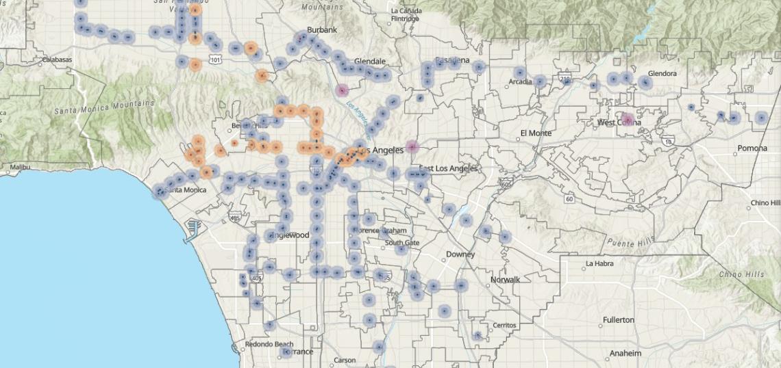
The Southern California Association of Governments has released its latest SB 79 map for the region, refining the location of under-construction and planned Metro rail stops within Los Angeles County.
SCAG's initial SB 79 map, which was released in June, was criticized for excluding stops on various planned rail lines such as the Sepuleveda Line and the K Line's northern extension. An updated to address missing stops followed in July, and the latest update released on October 29 further adjusts SB 79 zones based on more accurate location data for new and future transit hubs.
Adjustments have been made to the following existing or under construction transit lines which were already included in the map:
- D Line
- Century City
- Beverly Dr
- Westwood UCLA
- Westwood/VA Hospital
- A and E Lines (Regional Connector)
- Grand Ave Arts/Bunker Hill
- Historic Broadway
- Little Tokyo/Arts District
- A Line
- Glendora
- San Dimas
- Pomona North
- La Verne/Fairplex
- East San Fernando Valley Light Rail Transit Corridor
- Van Nuys/Metrolink
- Arleta [at Van Nuys]
- Laurel Canyon [at Van Nuys]
- Nordhoff [at Van Nuys]
- Van Nuys/Metro G Line
- Roscoe [at Van Nuys]
- Van Nuys/San Fernando
- Sherman Way [at Van Nuys]
- Vanowen [at Van Nuys]
- Victory [at Van Nuys]
- Woodman [at Van Nuys]
- G Line
- Van Nuys Station
Updates have also been made to account for the adopted locally preferred alternatives for these future transit lines:
- K Line Northern Extension
- Crenshaw/Adams
- Midtown Crossing
- Wilshire/Fairfax
- Fairfax/3rd
- La Cienega/Beverly
- San Vicente/Santa Monica
- Fairfax/Santa Monica
- Santa Monica/La Brea
- Hollywood/Highland
- Hollywood Bowl
- Sepulveda Transit Corridor
- Ventura Boulevard
- UCLA
- Santa Monica Boulevard
- Eastside Phase 2A and 2B
- Atlantic/Pomona
- Atlantic/Whittier
- Commerce/Citadel
- Greenwood/Washington
- Rosemead/Washington
- Norwalk/Washington
- Lambert/Washington
The rules for SB 79 zones, and related by the City of Los Angeles, are as follows:
 SB 79 development standardsCity of Los Angeles
Although SCAG maps establish the official boundaries for SB 79 in Southern California, local development rules remain in flux. While cities like Santa Monica and Los Angeles have enacted local plans to blunt or delay the law's impacts, Beverly Hills recently faced a major setback. Despite being one of the first to implement an alternative local plan, Beverly Hills was recently forced to rescind its efforts after state regulators reversed their initial approval and declared the city non-compliant with SB 79.
SCAG's map is likely to change again in the near future to account for the launch of the long-awaited the OC Streetcar line.
Follow us on social media:
Twitter / Facebook / LinkedIn / Threads / Instagram / BlueSky